Oct 17, 2026 · @Gabor Varga
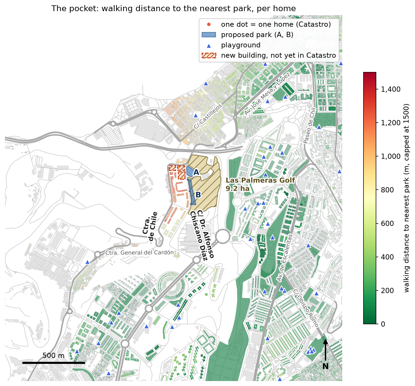
About 2,000 residents in 816 homes along Carretera de Chile and Calle Doctor Alfonso Chiscano Díaz live more than 1 km on foot from the nearest public park and almost 900 m from the nearest playground. That places them among the worst-served 12% of residents in Las Palmas de Gran Canaria.
Next to these homes sit Las Palmeras Golf, a 9.2 ha municipal golf course that is not open to the public as a park, and an abandoned plot where a wellness centre was started and never finished.
| Measure (pocket of 26 apartment buildings, 816 homes) | Value |
|---|---|
| Median walk to nearest public park (≥ 2,500 m²) | 1,145 m |
| Median walk to nearest playground | 877 m |
| City residents with a park closer than the middle of the pocket | 88.7% |
| City residents with a playground closer than the middle of the pocket | 87.7% |
We ask the Ayuntamiento to turn the abandoned plot (0.38 ha) and a strip of the municipal golf course along Calle Doctor Alfonso Chiscano Díaz (0.55 ha, about 6% of the course) into a free public park with a playground. Together they would put every home in the pocket within 500 m of a park and give about 6,400 people across the city a park within 500 m.
The area studied is the northern edge of the barrio of Las Torres, around Carretera de Chile and Calle Doctor Alfonso Chiscano Díaz. Residents often call it the Negrín area, after the nearby hospital; official statistics (ISTAC) count it as part of Las Torres.
Immediately east of the homes lies Las Palmeras Golf, an 18-hole par-3 course at Avenida Doctor Alfonso Chiscano Díaz s/n, founded in 2006. It is part of a sports centre that also has a spa, gym, pool and paddle courts (Hello Canary Islands). It is the largest open green space near these homes, but it is a paid sports facility, not a public park.
The golf course land is municipal. The course is a municipal sports facility run through the Instituto Municipal de Deportes (IMD) (Ayuntamiento).
“Public use” means open to anyone who pays to play. An 18-hole round is listed at €28.80, with reduced rates for children, students and over-65s (1golf.eu; prices may have changed). Like any golf course, it is not a place where non-players can walk or children can play. Public ownership has not given the neighbourhood a public green space.
Because the land is public and the city kept the right to recover it, setting aside part of it as a park is a decision the Ayuntamiento can take. Its classification in the Plan General still needs to be confirmed.
Beside the course is an abandoned plot. Between the two halves of the course, next to the car park it shares with the golf club, lies a 0.38 ha plot. Neighbours report that a wellness centre was started there and abandoned when the developer went bankrupt; we found no published record of that project. The plot is not part of the course as mapped. The municipal sports complex is listed at 111,648 m² (Ayuntamiento), about 2 ha more than the 9.2 ha course, so the plot may belong to the municipal site. This needs checking in the Catastro.
The city has committed to child-friendly public space. Las Palmas de Gran Canaria has been a UNICEF Child-Friendly City (Ciudad Amiga de la Infancia) since 2021 (Ayuntamiento) and renewed the recognition in April 2026 (RTVC). Its II Plan Municipal de Infancia y Adolescencia 2025–2028, approved by the city council in May 2025, proposes creating parks and sports areas adapted to the needs of children and adolescents (Canarias7).
The pocket is exactly where that commitment is missing: a neighbourhood of apartment blocks, averaging more than 30 homes per building, home to many young families, with no park within a kilometre on foot and no playground within 750 m.
We measured, for every residential building in the city, the walking distance along real streets and paths to the nearest public park and the nearest playground. All data are open and the analysis can be repeated by anyone.
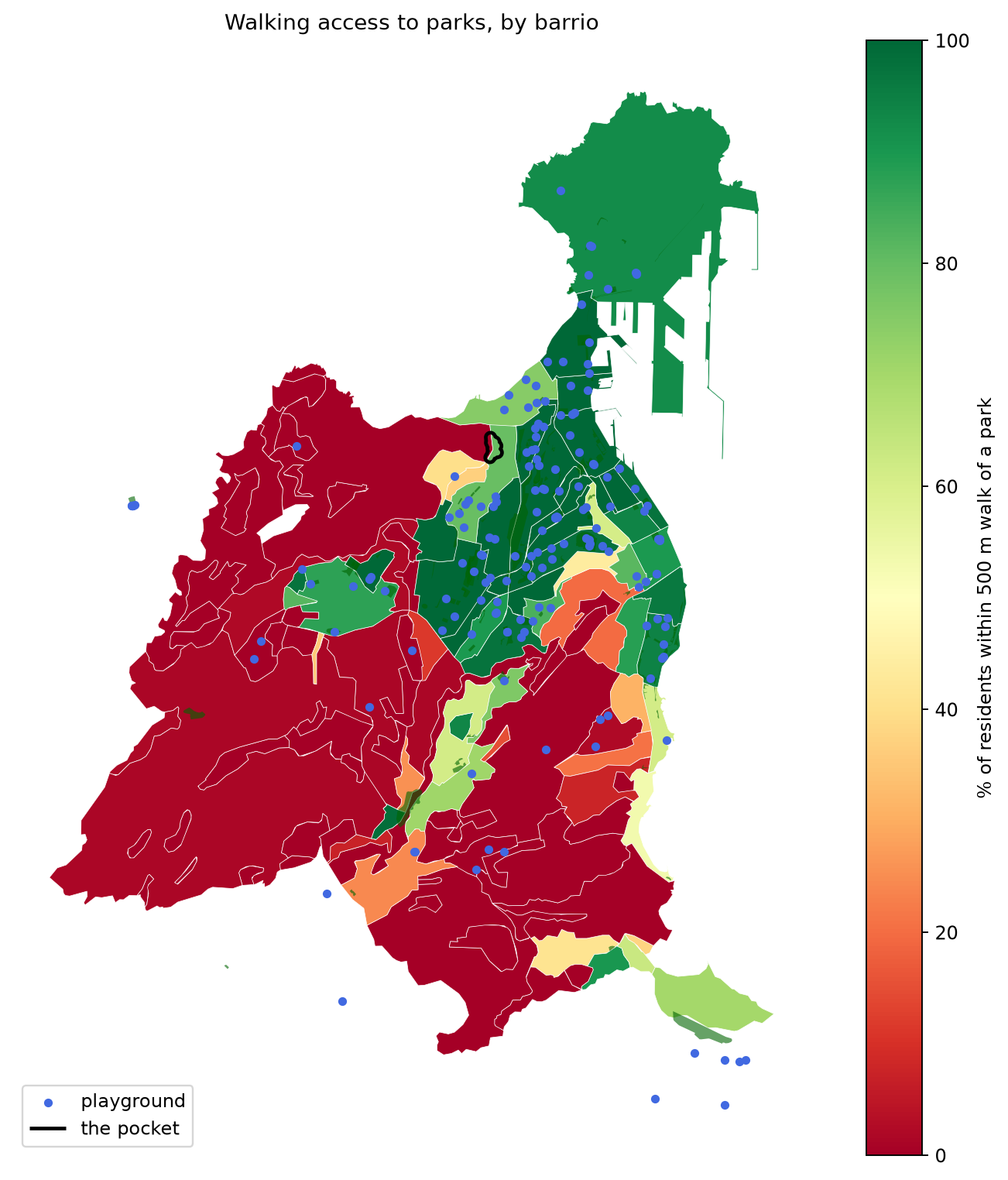
The homes along Carretera de Chile and Calle Doctor Alfonso Chiscano Díaz form a clear pocket with no park or playground within a reasonable walk, inside a barrio that is otherwise well served.
1. The pocket is among the worst-served places in the city. From a home in the middle of the pocket, on Carretera de Chile, the nearest public park is a 1,100 m walk and the nearest playground 921 m. 88.7% of the city’s residents live closer to a park, and 87.7% closer to a playground.
2. About 2,000 people live in it. The Catastro records 816 homes in the pocket’s 26 residential buildings. By nearest street, 24 buildings are on Carretera de Chile, 1 on Calle Doctor Alfonso Chiscano Díaz and 1 on El Horno de Cal. At 2.5 people per home that is about 2,000 residents; the count includes any empty or second homes.
3. No home in the pocket is within 750 m of either. The median walk is 1,145 m to a park and 877 m to a playground. The worst-placed building is 1,247 m from a park and 1,124 m from a playground.
4. Barrio averages hide the pocket. Las Torres as a whole has 79% of residents within 500 m of a park and ranks 74th of 106 barrios (1 = worst). Its gap is concentrated at the northern edge: 14% of Las Torres residents are more than 1 km from a park, and the pocket is where they live.
| Area | Residents within 500 m of a park | Median walk to a park |
|---|---|---|
| The pocket | 0% | 1,145 m |
| Las Torres (whole barrio) | 79% | 154 m |
| Whole city | 77% | – |
The abandoned plot plus a strip of the golf course along Calle Doctor Alfonso Chiscano Díaz would bring every home in the pocket within 500 m of a park, using about 6% of the course. We modelled the whole course and two areas drawn by residents: the abandoned plot and a strip between Calle Doctor Alfonso Chiscano Díaz and the course’s ball-stop net.
| Area turned into a public park | Size | Golf course land used | Pocket: median walk to a park | Pocket homes within 500 m | People citywide gaining a park within 500 m |
|---|---|---|---|---|---|
| Today | – | – | 1,145 m | 0% | – |
| Proposed: abandoned plot + residents’ strip | 0.93 ha | 6% | 258 m | 100% | ~6,400 |
| Abandoned plot only | 0.38 ha | none | 369 m | 74% | ~5,200 |
| Residents’ strip only | 0.55 ha | 6% | 258 m | 100% | ~4,900 |
| Whole golf course | 9.2 ha | 100% | 220 m | 100% | ~8,000 |
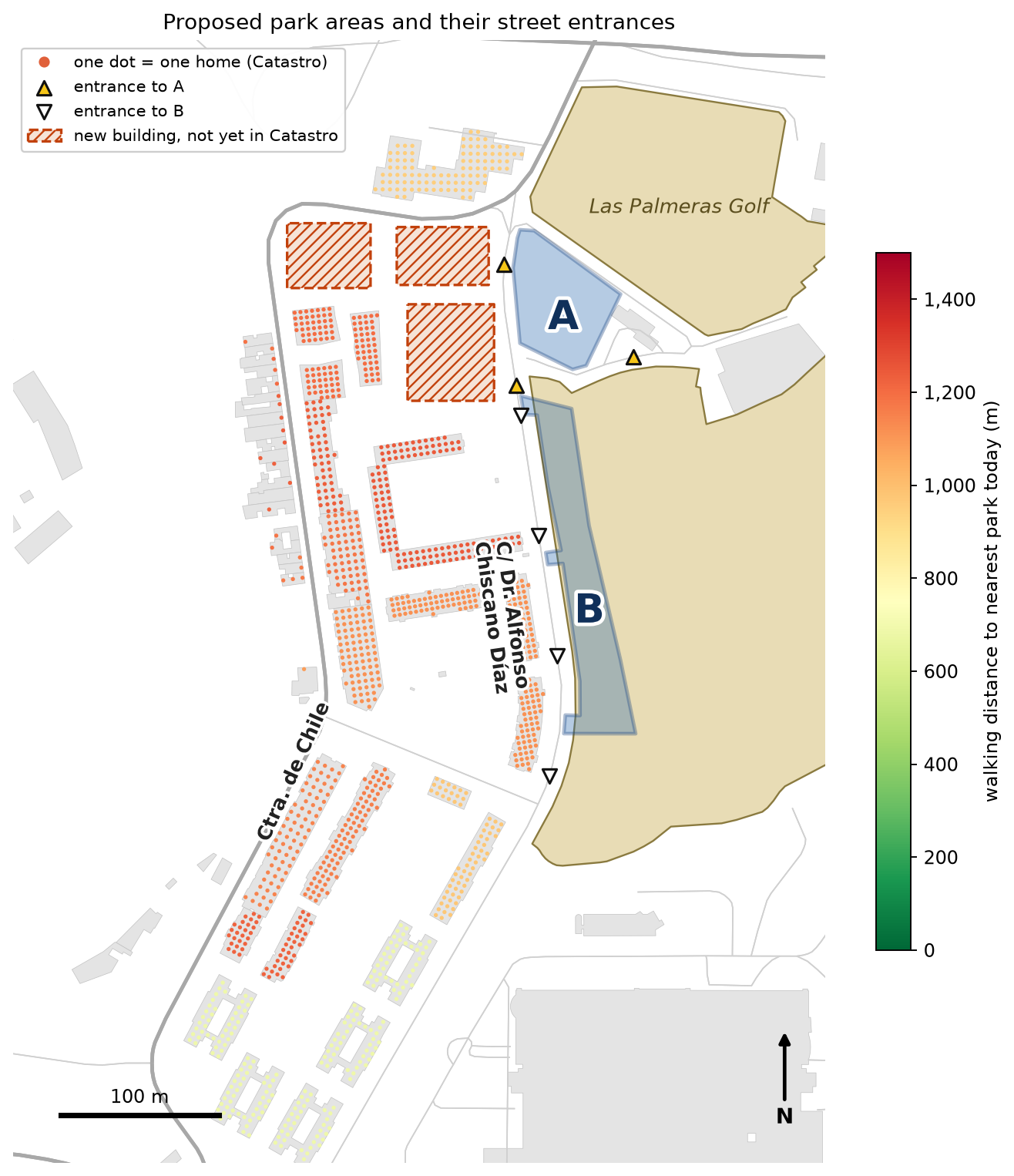
People counts are Catastro homes × 2.5 people. Each area is assumed to be entered from every street point within 30 m of its edge. The residents’ strip would replace the four practice greens; whether they can move elsewhere on the course needs discussing with the club.
The core finding is robust to the choice of minimum park size, but four points must be checked before these numbers are presented as final.
Other notes: barrio boundaries are the 2018 ISTAC edition, and ISTAC has no barrio called Negrín, so the area appears under Las Torres. The barrio comparison uses 106 barrios with at least 30 residential buildings.
We ask the Ayuntamiento de Las Palmas de Gran Canaria for three things, in order of how quickly they can be done.
Next steps for neighbours:
The analysis, maps and code are available on request so the Ayuntamiento’s technical staff can reproduce every figure.
Sources: OpenStreetMap contributors (parks, playgrounds, walking network, October 2026); Dirección General del Catastro, INSPIRE buildings (homes per building, October 2026); ISTAC barrio boundaries 2018 and barrio classification 2024 (datos.canarias.es); Las Palmeras Golf, 1golf.eu; Las Palmeras Golf, Hello Canary Islands.